Page made by: Jinn Guo
Source: Google Earth
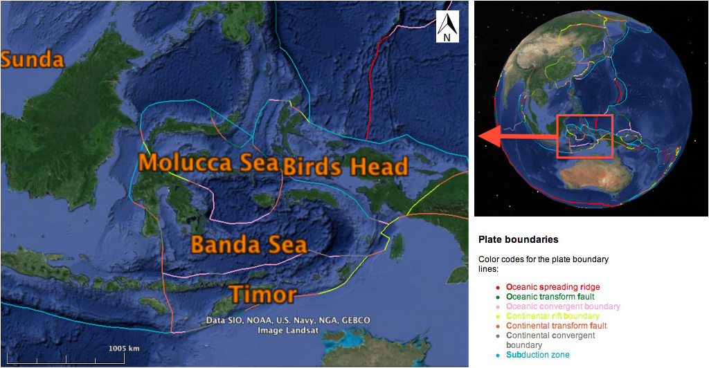
molucca sea plateTECTONICS Molucca Sea plate (MS) includes the north arm of Sulawesi and Molucca Sea. It has been confirmed that two subduction zones are converging in the Molucca Passage: the eastward-moving Sangihe subduction zone at the north tip of Sulawesi and the westward-moving Halmahera subduction zone locating along the west margin of MS. Talaud Mayu Ridge forms in between these two zones, marking the location of thrust contact. More recent studies suggest that MS has been completely subsumed by Sangihe and Halmahera (Silver and Moore, 1978). This tectonic setting is unique globally because it is the only example of an active arc-arc collision consuming an oceanic basin by opposite-direction subductions. 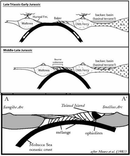
Fig 2. Evolution on Molucca sea plate through time.
Upper: late Triassic to early Jurassic, by which time it is still a mountain province.
Mid: Middle-late Jurassic
Lower: present. The oceanic crust has been completely subducted.
(Modified from Schwartz et al., 2009)
|
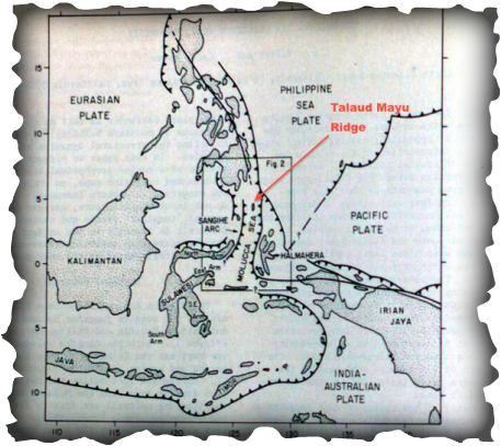
Fig 1. Molucca Sea region with major geographic and tectonic features. Teeth represent the motion of thrust faults or subduction zone as observed on the surface.
(Modified from Silver and Moore, 1978)
This tectonic setting is unique because it is the only example of an active arc-arc collision consuming an oceanic basin by opposite-direction subductions.
GEOLOGY Volcanic activities on Sulawesi were dated as old as 17ma, which suggests the island was formed near the lower Miocene, while the Halmahera subduction zone was observed to have formed around the late Cenozoic to Eocene. The west arm of Sulawesi is mainly composed of schist belt while the east arm is dominated by ophiolite belt. Similar rock type distribution is found on Halmahera; western Halmahera contains mostly schist and the east side has more ultramafic and metamorphic rocks. According to Silver and Moore (1978), the most plausible explanation for this similarity is that the plate was subducting westwards in early Cenozoic, and later on flipped to subduct eastwards in the late Cenozoic, to form the present sense of motion. |
Banda Sea Plate (BS)
|
Banda Sea plate (BS) is located at the center of three other major plates: the Indo-Australia Plate, the Pacific Plate, and the Eurasian Plate. It was suggested that BS overlies oceanic crust, but more recent studies show that it is plausible that BS is a piece of the Indian Ocean plate that has been trapped since Cretaceous to Tertiary times (Lee & McCabe, 1986). The converging and colliding of the other three large plates around this small plate result in various arcs and troughs in BS. The major one, Banda Arc is located at the south of BS, along its boundary with Timor Plate. This arc extends all the way from Banda Basin towards west, tracing from Bali to eastern Java. The series of volcanoes showing in Fig.3 indicates the trace of Banda Arc. |
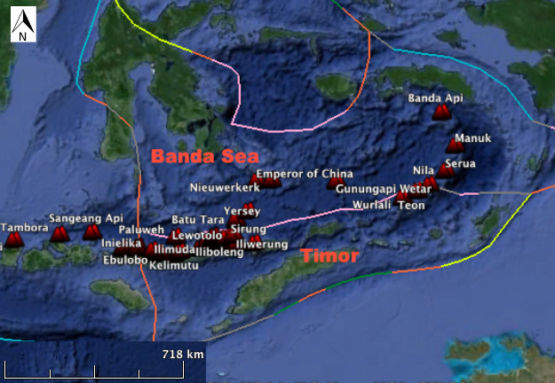
Fig.3 Banda Sea and Timor plates with major volcanoes (red triangles). (Modified from Google Earth)
|
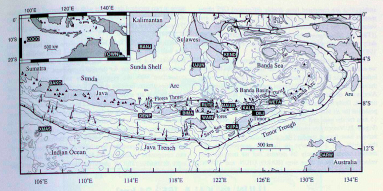
Fig 4.
Eastern Indonesian island arc region. Bold lines represent major faults; teeth on the faults refer to the motion of thrust faults. Arrows are earthquake slip vectors pointing in moving direction of hanging wall relative to footwall. Triangles denote volcanoes.
(Modified from Genrich et al., 1996)
Banda Arc is generally considered to have two parts: the "inner volcanic arc" and the "outer non-volcanic arc". The inner arc consists of a string of islands from Java to the west of Timor. This young arc only started to form from Miocene and is still active today. The volcanoes are mainly formed on oceanic crust. The older outer arc starts from Savu island (located at the west tip of Timor) to Wetar, at which point the arc starts to bend northward and extend to the southern boundary of MS. The bending feature of Banda Arc is formed due to the collision of Australian continental plate with Banda Arc. Australian continental plate is thick (35~40km) but not dense, which prevent it from subducting to greated depth under the arc but to push the arc to bend northward. The bended outer arc thus is not volcanic anymore because subduction zone underneath has been blocked. (Genrich et al., 1996)
TIMOR PLATE (TI)
|
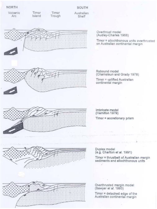
Timor plate (TI) sits at the north of BS. The mechanism of its formation is still not clearly understood. Earlier researches show that the relative position between Australia and Timor Island was fixed until Mid-Late Miocene, by which time Australian Plate collided with Eurasian Plate. This suggests that TI was a part of Australian continental plate until the collision. (Carter et al., 1976) It is also possible that TI was formed after the beginning of subduction of Australian plate, and later started to accrete onto the north margin of Australia plate. More recent data shows that the velocity of Timor trough, locating at the north boundary of TI, is moving with velocity less than 10mm/yr, which means that TI is no longer active as a thrust and has accreted onto Australia continental plate. (Genrich et al., 1996) (Timor paper). Fig. 5 Different interpretations of the origin of Timor Island. (Harris et al., 2000) |
|
Timor Island and its surrounding islands are on the young uplift created by collision of Australian plate and Banda Arc. It is a part of the non-volcanic Banda Arc. This makes it a rich source of ore deposits as shallow submarine volcanoes (2km) are found beneath this area. Being formed around 4.8 Ma, these volcanoes have abundant sulfide, barite and gold accumulated on its flanks. |
Fig. 6 Timor Island in Southwest Pacific.
(Map by Anonymous)
|
bird's head plate (bh)
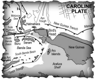 Fig 7. Geographic and tectonic features of
Bird's Head area.
(Source: Hall, 2002)
Fig 7. Geographic and tectonic features of
Bird's Head area.
(Source: Hall, 2002)
Birds Head Plate (BH) incorporates the western end of the island of New Guinea. It is subducting towards the Sunda Plate at a velocity very similar to Caroline Plate, North Bismarck Plate, and eventually the Pacific Plate. However whether BH is connected to Pacific Plate is still in doubt (Bird, 2003).
There is a series of volcanoes that lines the northwest end of BH. They are formed as the result of the collision of BH and MS, as previously discussed in the MS section (Fig.8).
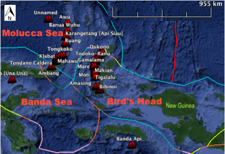
Fig 8. Bird's Head plate with major volcanoes.
(Source: Google Earth)
|
The Seram Basin at south margin of BH marks the contraction between New Guinea and Seram Island (Fig.7). It has been observed that the Central Range in New Guinea was formed by folding in the early Pliocene. This folding created an angular unconformity that cuts sediments as old as Middle Jurassic. The southern side of the fold later on dips southwards to the Seram trough to the present. Stratigraphic evidence confirms that the contraction in the trough we see today did not occur until late Pliocene. This suggests that Seram trough is a foredeep that is created as a result of loading of orogeny, rather than a subduction trench. (Pairault et al., 2003). |
References:
Bird, P. (2003). "An Updated Digital Model of Plate Boundaries." Geochemistry, Geophysics, Geosystems 4 (3).
Genrich, J. F., Y. Bock, R. McCaffrey, E. Calais, C. W. Stevens, and C. Subarya (1996), "Accretion of the southern Banda arc to the Australian plate margin determined by Global Positioning System measurements", Tectonics, 15(2), 288–295.
Silver, E. A., and J. C. Moore (1978), "The Molucca Sea Collision Zone, Indonesia", J. Geophys. Res.,83(B4), 1681–1691,
Lee, C. -S and R. Mccabe. (1986). "The Banda-Celebes-Sulu Basin: A Trapped Piece of Cretaceous-Eocene Oceanic Crust?" Nature 322 (6074): 51-54.
Duffy, B., Quigley, M., Harris, R., & Ring, U. (2013). "Arc-parallel extrusion of the timor sector of the banda arc-continent collision", Tectonics, 32(3), 641-660.
Environment and Development Division. "Geology and Mineral Resources of Timor-Leste."Atlas of Mineral Resources of the ESCAP Region 17 (2004): 1-36.
Harris, R., J. Kaiser, A. Hurford, and A. Carter. 2000. "Thermal History of Australian Passive Margin Cover Sequences Accreted to Timor during Late Neogene Arc-Continent Collision, Indonesia." Journal of Asian Earth Sciences 18 (1): 47-69
Carter, D. J., M. G. Audley-Charles, and A. J. Barber. 1976. "Stratigraphical Analysis of Island Arc-Continental Margin Collision in Eastern Indonesia." Journal of the Geological Society 132 (2): 179-198.
Pairault, A. A., R. Hall, and C. F. Elders. 2003. "Structural Styles and Tectonic Evolution of the Seram Trough, Indonesia." Marine and Petroleum Geology 20 (10): 1141-1160.
Hall, R. 2002. "Cenozoic Geological and Plate Tectonic Evolution of SE Asia and the SW Pacific: Computer-Based Reconstructions, Model and Animations." Journal of Asian Earth Sciences 20 (4): 353-431.
